Property Record
1550 Phillips St, Dyersburg, TN 38024
NEARBY LISTINGS FOR SALE OR LEASE
-
-
View all Dyersburg listings for sale on LoopNet.com
Property Detail
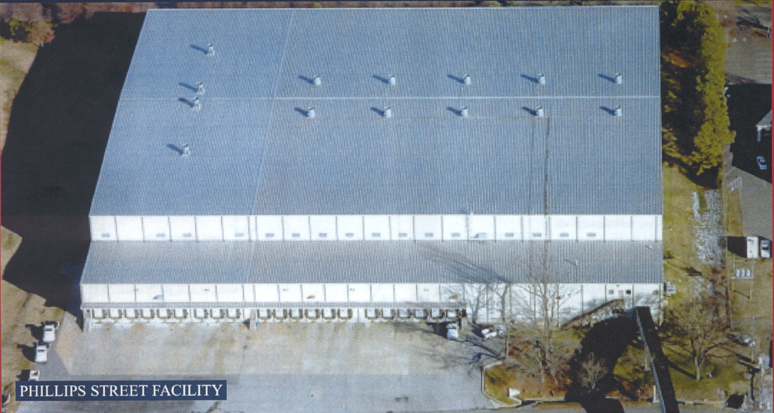
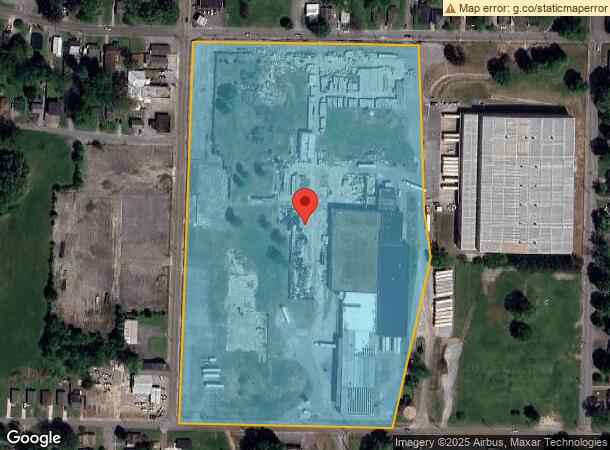
1550 Phillips St
088M-K-001.00
PLANT
Warehouse
Dyer
X
Tennessee
47045C0211E
20 AC
2024
Tennessee West Area
2024
Other Market Areas
964300
Dyersburg, TN
40,000 SF
DEMOGRAPHICS near 1550 Phillips St
1 Mile
3 Mile
5 Mile
2024 Total Population
6,326
17,012
22,216
2029 Population
6,279
16,872
21,975
Pop Growth 2024-2029
(0.74%)
(0.82%)
(1.08%)
Average Age
38
39
40
2024 Total Households
2,501
6,910
8,979
HH Growth 2024-2029
(0.76%)
(0.85%)
(1.09%)
Median Household Inc
$44,545
$46,195
$49,216
Avg Household Size
2.40
2.30
2.40
2024 Avg HH Vehicles
1.00
2.00
2.00
Median Home Value
$106,370
$138,947
$139,970
Median Year Built
1966
1973
1976
Nearby Places
- Restaurants
- Banks
- Shops
- Fitness
- Groceries
PUBLIC TRANSPORTATION
COMMUTER RAIL
Newbern-Dyersburg Amtrak Station (City of New Orleans - Amtrak)
DRIVE
WALK
Distance
Newbern-Dyersburg Amtrak Station (City of New Orleans - Amtrak)
17 min
8.5 mi
Freight Ports
Tulsa Port of Inola
DRIVE
WALK
Distance
Tulsa Port of Inola
504 min
414.4 mi
SALE & LEASE HISTORY
LISTING DATE
SALE/LEASE

Aug 26, 2020
For Sale
Nearby Properties
Address
Land Use
TOTAL SIZE
Lot Size
Zoning
Address
Land Use
TOTAL SIZE
Lot Size
Zoning
200,708 SF
12.78 AC
Address
Land Use
TOTAL SIZE
Lot Size
Zoning
150,025 SF
91.14 AC
Address
Land Use
TOTAL SIZE
Lot Size
Zoning
218,120 SF
30 AC
Address
Land Use
TOTAL SIZE
Lot Size
Zoning
200,955 SF
11.50 AC
Address
Land Use
TOTAL SIZE
Lot Size
Zoning
86,005 SF
12.60 AC
Address
Land Use
TOTAL SIZE
Lot Size
Zoning
11,817 SF
3.26 AC
Address
Land Use
TOTAL SIZE
Lot Size
Zoning
83,497 SF
13.10 AC
Address
Land Use
TOTAL SIZE
Lot Size
Zoning
18,318 SF
2.91 AC
Address
Land Use
TOTAL SIZE
Lot Size
Zoning
110,469 SF
13.69 AC
Address
Land Use
TOTAL SIZE
Lot Size
Zoning
37,236 SF
3 AC
Address
Land Use
TOTAL SIZE
Lot Size
Zoning
213,012 SF
Address
Land Use
TOTAL SIZE
Lot Size
Zoning
273,614 SF
63.80 AC
Address
Land Use
TOTAL SIZE
Lot Size
Zoning
114,820 SF
20 AC
Address
Land Use
TOTAL SIZE
Lot Size
Zoning
607,280 SF
73.20 AC
Address
Land Use
TOTAL SIZE
Lot Size
Zoning
21,023 SF
2 AC
Address
Land Use
TOTAL SIZE
Lot Size
Zoning
140,514 SF
48.71 AC
Address
Land Use
TOTAL SIZE
Lot Size
Zoning
42,717 SF
2.30 AC
Address
Land Use
TOTAL SIZE
Lot Size
Zoning
50,229 SF
6.66 AC
Address
Land Use
TOTAL SIZE
Lot Size
Zoning
27,045 SF
17.69 AC
Address
Land Use
TOTAL SIZE
Lot Size
Zoning
561 AC
Address
Land Use
TOTAL SIZE
Lot Size
Zoning
17,472 SF
8.10 AC
Address
Land Use
TOTAL SIZE
Lot Size
Zoning
94,857 SF
6.75 AC
Address
Land Use
TOTAL SIZE
Lot Size
Zoning
17,524 SF
3.30 AC
Address
Land Use
TOTAL SIZE
Lot Size
Zoning
24,631 SF
0.33 AC
Address
Land Use
TOTAL SIZE
Lot Size
Zoning
102,644 SF
15.63 AC
Address
Land Use
TOTAL SIZE
Lot Size
Zoning
44,903 SF
2.42 AC
Address
Land Use
TOTAL SIZE
Lot Size
Zoning
10,574 SF
33 AC
Address
Land Use
TOTAL SIZE
Lot Size
Zoning
9,058 SF
14.19 AC
Address
Land Use
TOTAL SIZE
Lot Size
Zoning
285,740 SF
26.50 AC
Address
Land Use
TOTAL SIZE
Lot Size
Zoning
46,655 SF
4.90 AC
The World's #1 Commercial Real Estate Marketplace
Connect with us
© 2025 CoStar Group
The information above has been obtained from sources believed reliable. While we do not doubt its accuracy we have not verified it and make no guarantee, warranty or representation about it. It is your responsibility to independently confirm its accuracy and completeness. Any projections, opinions, assumptions, or estimates used are for example only and do not represent the current or future performance of the property. The value of this transaction to you depends on tax and other factors which should be evaluated by your tax, financial, and legal advisors. You and your advisors should conduct a careful, independent investigation of the property to determine to your satisfaction the suitability of the property for your needs.